Vietnam Typhoons in September
A list of typhoons and tropical depressions which influence Vietnam in September.
-
Can Your Holidays in Southern Vietnam Be Affected by A Typhoon in Northern Vietnam?

So you are on holidays in Vietnam and there is news that a typhoon is looming in Northern Vietnam. Would your trip in the South of Vietnam be affected by the coming typhoon in Northern Vietnam? The simple answer is YES!
-
Super Typhoon (Mangkhut), Tropical Storm No. 6 in Vietnam in 2018
13-September-2018: Mangkhut is 830km east south-east of Luzon (The Philippines). The Super Typhoon carries sustained winds of 200-230km/h and is heading west northwest. The question where Mangkhut is making landfall remains unclear for now.
-
Tropical Depression (Kajiki) 1-September-2019
1-September-2019
01:00 A.M The tropical depression which had formed on 30-August-2019 has entered the area of the East Sea at 740km east north-east of the Paracel Islands (Vietnam) carrying sustained winds of 40-60kph. The projected path in the next 24 hours is west.
-
Tropical Depression 2-September-2019
2-September-2019
A tropical depression has formed in the area east of the Paracel Islands (Vietnam).
04:00 A.M The tropical depression is to the southeast of the Paracel Islands (Vietnam) carrying sustained winds of 40-50kph. The projected path in the next 24 hours is nne.
-
Tropical Depression in Vietnam in September 2023

24-September-2023
The air trough to the southeast of the Paracel Islands (Hoang Sa Islands, Vietnam) has strengthened to be a tropical depression. The projected path in the next 24 hours is west.
-
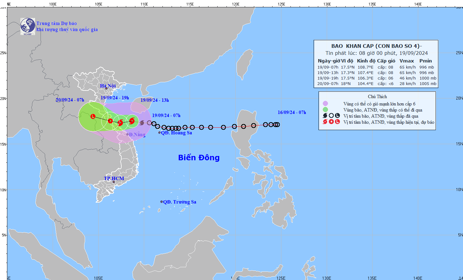
Typhoon No. 4 in Vietnam in 2024 (Soulik)

In the morning of 19-September-2024, the tropical depression has strengthened to be a typhoon, No. 4 in Vietnam in 2024.
-
Typhoon No. 5 in Vietnam in 2020 (Noul)
15-September-2020 The low-pressure air trough has strengthened to be a tropical depression (No. 5 in Vietnam in 2020) on the East Sea of Vietnam.
17:00 The tropical depression is packing sustained winds of 40-50kph. The projected path in the next 24 hours is wnw.
16-Sept-2020: The tropical depression has strengthened to be a typhoon, Typhoon No. 5 in Vietnam in 2020 (internationally coded Noul).
04:00 A.M The typhoon is 200km nnw of the Palawan Island (The Philippines) packing sustained winds of 60-75kph. The projected path in the next 24 hours is wnw.
10:00 A.M The typhoon is 750km southeast of the Paracel Islands (Vietnam) packing sustained winds of 60-75kph. The projected path in the next 24 hours is wnw.
17-Sept-2020:
04:00 A.M The typhoon is 380km southeast of the Paracel Islands (Vietnam) carrying sustained winds of 75-100kph. The projected path in the next 24 hours is wnw, the distance covered per hour is 20km.
10:00 A.M The typhoon is 340km southeast of the Paracel Islands (Vietnam) carrying sustained winds of 90-100kph. The projected path in the next 24 hours is wnw, the distance covered per hour is 20km.
13:00 The typhoon is 220km southeast of the Paracel Islands (Vietnam) carrying sustained winds of 75-100kph. The projected path in the next 24 hours is wnw, the distance covered per hour is 20km.
18-Sept-2020:
04:00 A.M The typhoon is right on the sea area of Quang Binh - Quang Nam carrying sustained winds of 75-100kph. The projected path in the next 12 hours is west, the distance covered per hour is 12km.
08:00 A.M The typhoon is right on the sea area of Quang Binh - Da Nang carrying sustained winds of 75-90kph. The projected path in the next 12 hours is west, the distance covered per hour is 25km.
09:00 A.M The typhoon is right on the coast of Quang Tri - Hue carrying sustained winds of 75-100kph. The projected path in the next 12 hours is wnw, the distance covered per hour is 25km.
09:30 A.M The typhoon makes landfall in Hue and then brushes through Quang Tri weakening to be a tropical depression. The projected path in the next 12 hours is west, the distance covered per hour is 25km.
-
Typhoon No.5 in Vietnam in 2018 (Barijat)
11Sept2018: Tropical depression is strengthening to be a tropical storm, a typhoon - Barijat, the 5th tropical storm which hits Vietnam in 2018. At the same time, another already formed typhoon Mangkhut in the northwest of the Pacific Ocean is to strengthen to be a Super Typhoon which may barrel towards the North of the East Vietnam Sea in the next 4 days.
-
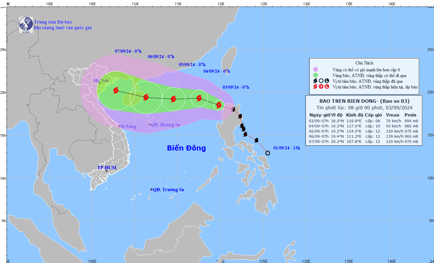
Typhoon Yagi, No. 3 in Vietnam in 2024 September

In the morning of 3-September-2024, Typhoon internationally coded Yagi entered the East Vietnam becoming typhoon No.2 in Vietnam in 2024.
07:00 A.M Typhoon Yagi is in the area to the northwest of the East Vienam Sea carrying sustained winds of 62-74kph. The projected path is wnw covering 20-25kph.

Typhoon Yagi, No. 3 in Vietnam in 2024 September 13:00 hours: Typhoon Yagi is to the east of the north of the East Vietnam Sea carrying sustained winds of 75-88kph. The projected path is wnw covering 15kph.
19:00 hours: Typhoon Yagi is to the east of the north of the East Vietnam Sea carrying sustained winds of 89-102kph. The projected path is wnw covering 10kph.
04-September-2024
04:00 A.M: Typhoon Yagi is to the east of the north of the East Vietnam Sea packing sustained winds of 103-117kph. The projected path is wnw covering 10kph.
07:00 A.M: Typhoon Yagi is to the northeast of the East Vietnam Sea packing sustained winds of 103-117kph. The projected path is wnw covering 10kph.
13:00 hours: Typhoon Yagi is to the northeast of the East Vietnam Sea, 710km east of the Hainan Island, packing sustained winds of 118-133kph. The projected path is wnw covering 5-10kph.
16:00 hours: Typhoon Yagi is to the northeast of the East Vietnam Sea, 680km east of the Hainan Island, packing sustained winds of 118-149kph. The projected path is wnw covering 5-10kph.
05-September-2024
04:00 A.M: Typhoon Yagi is 550km east of the Hainan Island packing sustained winds of 167-183kph. The projected path is wnw covering 10kph.
07:00 A.M: Typhoon Yagi is 520km east of the Hainan Island packing sustained winds of 167-183kph moving westward. The projected path is wnw covering 10kph.
10:00 A.M: Typhoon Yagi is 490km east of the Hainan Island packing sustained winds of 184-201kph. The current path is westward and the projected path in the next 24 hours is wnw covering 10kph.
13:00 A.M: Typhoon Yagi is 460km east of the Hainan Island carrying sustained winds of 184-201kph. The current path is westward and the projected path in the next 24 hours is wnw covering 10kph.
16:00 A.M: Typhoon Yagi is 400km east of the Hainan Island carrying sustained winds of 184-201kph. The current path is westward and the projected path in the next 24 hours is wnw covering 10kph.
06-September-2024
04:00 A.M: Typhoon Yagi is 200km east of the Hainan Island, 620km southeast of the coast of Quang Ninh Province carrying sustained winds of 184-201kph moving westward covering 20kph. The projected path is wnw.
06:00 A.M: Typhoon Yagi is 168 km east of the Hainan Island, Province moving westward covering 15kph.
07:00 A.M: Typhoon Yagi is 130 km east of the Hainan Island, 600 km southeast of the coast of Quang Ninh Province moving westward covering 15kph.
10:00 A.M: Typhoon Yagi is 130 km east of the Hainan Island, 570 km southeast of the coast of Quang Ninh Province moving westward covering 15-20 kph.
13:00 hours: Typhoon Yagi is in the sea area to the northeast of the Hainan Island, 450 km east southeast of the coast of Quang Ninh Province with sustained winds of 184-201 kph moving wnw covering 15-20 kph.
16:00 hours: Typhoon Yagi is 420 km east southeast of the coast of Quang Ninh Province with sustained winds of 184-201 kph. The projected path is wnw covering 15-20 kph.
18:00 hours: Typhoon Yagi is 370 km east southeast of the coast of Quang Ninh Province with sustained winds of 184-201 kph. The projected path is wnw covering 15-20 kph.
19:00 hours: Typhoon Yagi is 360 km east southeast of the coast of Quang Ninh Province with sustained winds of 167-183 kph. The projected path is wnw covering 15-20 kph.
07-September-2024
04:00 A.M: Typhoon Yagi is 180 km southeast of Mong Cai City (Quang Ninh Province), 220km east southeast of the coast between Quang Ninh and Hai Phong, carrying sustained winds of 150-166 kph moving wnw covering 15-20kph. The projected path is wnw.
07:00 A.M: Typhoon Yagi is 160 km east southeast of the coast between Quang Ninh and Hai Phong, carrying sustained winds of 150-166 kph, moving wnw covering 15-20kph. The projected path is wnw.
09:00 A.M: (20.5, 107.8 )
Typhoon Yagi is in the sea area between Quang Ninh and Hai Phong, carrying sustained winds of 134-166 kph, moving wnw covering 20kph. The projected path is wnw.
10:00 A.M: (20.6, 107.6 )
Typhoon Yagi is in the sea area between Quang Ninh and Hai Phong, carrying sustained winds of 134-149 kph, moving wnw covering 15-20kph. The projected path is wnw.
11:00 A.M: (20.6, 107.5 )
Typhoon Yagi is in the sea area between Quang Ninh and Hai Phong, carrying sustained winds of 134-149 kph, moving wnw covering 15-20kph. The projected path in 3 hours is wnw.
12:00 A.M: (20.7, 107.3 )
Typhoon Yagi is in the sea area between Quang Ninh and Hai Phong, carrying sustained winds of 134-149 kph, moving wnw covering 15-20kph. The projected path in 3 hours is wnw.
13:00 hours:(20.8, 107.1 )
Typhoon Yagi makes landfall with the typhoon eye near Halong City, Quang Ninh Province.
22:00 hours (21.0, 105.5)
Typhoon Yagi is in the area of Hanoi, Vinh Phuc, Phu Tho and Hoa Binh Province carrying sustained winds of 62-88 kph.
08-September-2024:
04:00 A.M Typhoon Yagi has weaked to be a tropical depression with sustained winds of 39 kph.
10:00 A.M (21.44, 104.5)
The projected path is westward weakening further before melting away. This is the last update on Typhoon Yagi, Typhoon No 3 in Vietnam in 2024.


